Desert Landforms
 Wadi: An
arabic term that refers to a valley. In some cases it can also refer to
a dry riverbed that only experiences water when there is a heavy rain
fall. Unlike other valleys a wadi has been cut and eroded by water
however because it is in desert it rarely experiences any constant water
except for during the rainy season. Deposition is very common in a
feature such as this because of the fact that the water dries up and is
no longer able to carry a load of sediment that it has.
Wadi: An
arabic term that refers to a valley. In some cases it can also refer to
a dry riverbed that only experiences water when there is a heavy rain
fall. Unlike other valleys a wadi has been cut and eroded by water
however because it is in desert it rarely experiences any constant water
except for during the rainy season. Deposition is very common in a
feature such as this because of the fact that the water dries up and is
no longer able to carry a load of sediment that it has.  Playas:
An area of very dry land that is found below the sea level. Flats like
this often consist of fine grained sediments such as salts. During the
dry season the surface of the lake is usually hard and rough, where as
in the rainy season it gets wet and soft. The water usually creates a
small hole meaning there is a very shallow lake in the desert.
Playas:
An area of very dry land that is found below the sea level. Flats like
this often consist of fine grained sediments such as salts. During the
dry season the surface of the lake is usually hard and rough, where as
in the rainy season it gets wet and soft. The water usually creates a
small hole meaning there is a very shallow lake in the desert.  Alluvial Fans:
Often found in the desert where periodic flash floods occur. They often
have a large funnel shaped basin at the top which then creates a very
narrow stream which then opens into an alluvial fan at the end of its
course. These alluvial fans are often home to much more life and plants
then the rest of the desert due to the fact that any nutritional
sediment and water will end up here.
Alluvial Fans:
Often found in the desert where periodic flash floods occur. They often
have a large funnel shaped basin at the top which then creates a very
narrow stream which then opens into an alluvial fan at the end of its
course. These alluvial fans are often home to much more life and plants
then the rest of the desert due to the fact that any nutritional
sediment and water will end up here. 
Bajada: When many alluvial fans all come together in one place, or deposit in the same area it creates a bajada. Because of the gathering of all the fans it means that there is much more water and sediment then usual, and it is quite evenly spread out throughout the whole bajada.
 Mesa:
An elevated area of land that has a very steep sides and a flat top.
They are formed by the weathering and erosion of horizontally layered
rocks that are lifted by the tectonic activity of the area. Due to the
fact that some rocks erode faster then others, or others are stronger it
means that stronger rocks usually make it to the top and the weaker
rock is at the bottom.
Mesa:
An elevated area of land that has a very steep sides and a flat top.
They are formed by the weathering and erosion of horizontally layered
rocks that are lifted by the tectonic activity of the area. Due to the
fact that some rocks erode faster then others, or others are stronger it
means that stronger rocks usually make it to the top and the weaker
rock is at the bottom. 
 Canyon: A
deep ravine between cliffs, often carved into the landscape by a river.
They are formed when there is stronger rock on either side of where the
water is eroding. This means that the water is able to cut vertically
but not horizontally.
Canyon: A
deep ravine between cliffs, often carved into the landscape by a river.
They are formed when there is stronger rock on either side of where the
water is eroding. This means that the water is able to cut vertically
but not horizontally. Deflation Hollow or Basin:
Created by wind action. Fine grained particles from rocks that are
easily weathered are carried away creating a hollow. As the hollow
deepens they collect water during the rainy season. This water helps
speed up the weathering of the rock creating more particles to be blown
away by the wind. Due to this the hollow is able to deepen faster then
the rest of the land surrounding it, creating a large hole in the
ground.
Deflation Hollow or Basin:
Created by wind action. Fine grained particles from rocks that are
easily weathered are carried away creating a hollow. As the hollow
deepens they collect water during the rainy season. This water helps
speed up the weathering of the rock creating more particles to be blown
away by the wind. Due to this the hollow is able to deepen faster then
the rest of the land surrounding it, creating a large hole in the
ground. Barchan:
A sand ridge in the shape of an arc. Wind can often push the dunes
through the desert, and they can stretch in size anywhere from a few
meters to hundreds of meters long. They occur in the opposite direction
of the parabolic dunes and have their steep slip face on the concave
instead of the convex of the dune. Its extend arms are in front of it
instead of behind it.
Barchan:
A sand ridge in the shape of an arc. Wind can often push the dunes
through the desert, and they can stretch in size anywhere from a few
meters to hundreds of meters long. They occur in the opposite direction
of the parabolic dunes and have their steep slip face on the concave
instead of the convex of the dune. Its extend arms are in front of it
instead of behind it. Parabolic Dunes: U
or V-shaped mounds of sand that has an elongated arm that extends
upwind. They are always associated with vegetation which help anchor the
trailing arms of the dune. They are found in areas where the wind only
blows in one directions. Slip faces occur on the outer size of the
dune and on the slops of the elongated arms.
Parabolic Dunes: U
or V-shaped mounds of sand that has an elongated arm that extends
upwind. They are always associated with vegetation which help anchor the
trailing arms of the dune. They are found in areas where the wind only
blows in one directions. Slip faces occur on the outer size of the
dune and on the slops of the elongated arms.
Pedestal Rock: A large bolder on top of a very narrow base. This occurs when there is soft rock underneath that is easily eroded and harder rock on top that can not be eroded away.
 Arch:
Formed where there is soft rock surrounded by hard rock. Deep cracks
penetrate into the sandstone layer and erosion wears away exposing the
rocks layers and enlarging the surface cracks. Softer rock gets broken
away by wind and the little amount of rain forming arches where the soft
rock being broken away creates a hole in the harder rock.
Arch:
Formed where there is soft rock surrounded by hard rock. Deep cracks
penetrate into the sandstone layer and erosion wears away exposing the
rocks layers and enlarging the surface cracks. Softer rock gets broken
away by wind and the little amount of rain forming arches where the soft
rock being broken away creates a hole in the harder rock.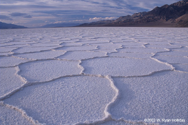 Salt Flats: Formed
where there are dry lake beds. It is an area of very dry land that
occurs below the sea level. It receives much of the sediment that is
deposited. In the case of a salt flat this if often salt deposits that
are left in a large dry lake bed.
Salt Flats: Formed
where there are dry lake beds. It is an area of very dry land that
occurs below the sea level. It receives much of the sediment that is
deposited. In the case of a salt flat this if often salt deposits that
are left in a large dry lake bed.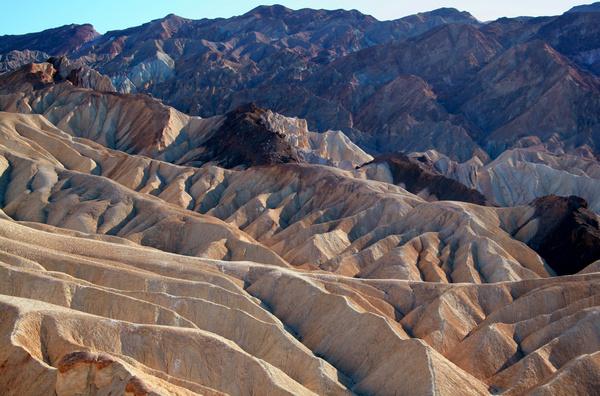 Badland:
Form where deep beds of easily eroded rock is exposed to erosion. The
infrequent heavy rains are able to cut out stream channels. This results
in gullies, carved hillsides and tall spires of the most resistant rock
to erosion.
Badland:
Form where deep beds of easily eroded rock is exposed to erosion. The
infrequent heavy rains are able to cut out stream channels. This results
in gullies, carved hillsides and tall spires of the most resistant rock
to erosion.Despite the lack or limited amount of precipitation in deserts, water is the major agent of erosion. Rainfall when it comes is brief and intense, and due to the hard rocky surface and limited vegetation tends to RUN OFF, creating FLASH floods. Because of limited precipitation PHYSICAL weathering is dominant. The main physical processes are HEATING-COOLING ,FREEZING-THAWING, and EXFOLIATION. Despite the fact that water is the most important agent of erosion in deserts, wind is quite important too. The action of wind eroding, transporting and depositing sediments is called EOLIAN processes. Wind erosion is common because there is little VEGETATION to hold the sand or sediment in place. Deflation is the large scale removal of sediment by wind. Abrasion is the process where sand carried by the wind “sandblasts” rocks. Regions covered in sand are called SAND SEAS or ERGS. Regions which are bare rock are called DESERT PAVEMENTS or REGS in Algeria.
No comments:
Post a Comment